Settlement infrastructure in the occupied West Bank is closely linked to the growth of the settler population, as it creates the physical conditions needed for expansion. The construction of roads and other public services makes settlements more accessible and attractive for new residents. As infrastructure improves, settlements can accommodate larger populations and connect more closely with each other and within the Green Line, encouraging further deliberate, calculated and unlawful settler demographic growth inside occupied territory.
While Israel has developed and expanded settlement infrastructure in the occupied West Bank since the outset of its occupation in 1967, as an integral part of the settlement enterprise and directly tied to expanding settlement demographics, another escalation in expanding settlement infrastructure can be observed following October 7, 2023, where “unauthorized” settler road construction spread across the West Bank, with settlers building at least 139 new roads totaling 116.4 kilometers between mid-2023 and mid-2024. These roads have increasingly been used to expand settlement control, connect settlement outposts, and access new Palestinian land. In the village of Nahalin, located southwest of Bethlehem, these settler roads have led to increased restrictions on access to agricultural land and movement. This has had a cumulative impact on livelihoods and land access amid broader, longer-standing restrictions on movement and land use.
Nahalin: Shrinking by Half as a Result of Israeli Annexation Policies
The village of Nahalin is located in the Bethlehem Governorate, southwest of Bethlehem city. It is home to several ancient historical sites from the Roman, Byzantine, and Canaanite periods. Today, Nahalin is surrounded by Israeli settlements and military infrastructure, including “Daniel” to the east, “Beitar Illit” and the “Givat military” base to the west, and “Gush Etzion” to the south, with only the Palestinian village of Hussan to the north providing a shared communal border.
In a grave development, Palestinian residents of Nahalin are facing a new encroachment on their land through the planned expansion of settlement infrastructure. On March 30, 2026, Israeli authorities issued an order to construct a settlement road that threatens to seize approximately 18,012 dunams of Nahalin land. The planned road, about 306 meters long, extends from near the settlement of “Neve Daniel”, located east/southeast of Nahalin, and runs northwest to connect it to a settlement outpost in that direction. This project includes paving and upgrading an existing dirt road, transforming what is currently a narrow path into a permanent road designed specifically to serve settler traffic. This project will connect the road network and infrastructure serving Israeli settlements, further isolating Nahalin’s lands and reducing Palestinian access to their agricultural lands.
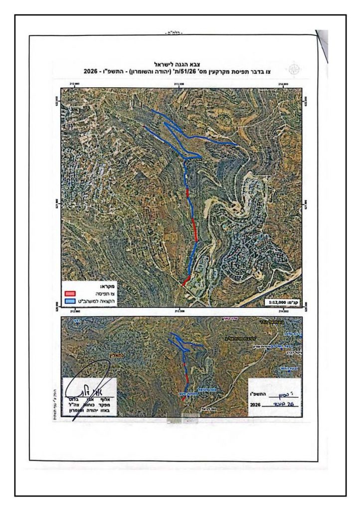
(Order regarding the seizure of land No. 26/51/seizure (Judea and Samaria))
Land confiscation and settler attacks in Nahalin reflect a sustained pattern of settlement expansion. In 1999, approximately 60% of Nahalin’s 12,000 dunams were confiscated for the expansion of surrounding illegal settlements, significantly reducing agricultural land. This was followed in 2009 by the construction of a settlement road linking “Beitar Illit” and “Givat Ze’ev”, further fragmenting the village’s land. In subsequent years, settler attacks continued to impact agricultural resources, including the destruction of over 50 olive trees in 2013, followed by the cutting of 25 additional olive trees in October 2019.
The cumulative impact of Israel’s policies in the area has resulted in the continued loss and fragmentation of Nahalin’s land: from around 24,000 dunams to approximately 12,000 dunams by 2022, increasingly surrounded by settlements and military infrastructure. More recently, in June 2026, bulldozers began clearing additional land west of Bethlehem for settlement expansion under military protection, while residents were denied access to their land.
The Socio-Economic Impact of the New Settlement Road Network in Nahalin:
Restrictions on access to land and agricultural infrastructure have increasingly reshaped the socio-economic structure of Nahalin, with agriculture becoming the dominant yet increasingly constrained source of livelihood. Testimonies gathered from local officials and residents illustrate the cumulative impact of these factors on the community’s primary sources of subsistence.
Testimony 1: Local Official from Nahalin
According to the Local Official, agriculture has become the primary source of income, rising from approximately 40% to nearly 80% of the local economy in recent years, largely due to limited employment opportunities and to Israel’s revocation of all work permits post the events of 7 October 2023.
The interviewee also reported severe restrictions on access to agricultural areas outside designated residential zones, as well as the presence of settlement outposts surrounding the city. He added, “There is a military order prohibiting Palestinians from approaching within 200 meters of settlement fences,” Which has effectively resulted in the loss of adjacent agricultural land.
He further explained that Ein Faris, considered the breadbasket of Nahalin, has faced increasing access restrictions, particularly since October 7, 2023. He added, “Farmers enter the area secretly, fearing arrest upon arrival, so they go to their lands in the early morning hours.” The interviewee also mentioned a settler who has been residing between the borders of Nahalin and al-Khader since the beginning of the war. According to the interviewee, “A military road was then constructed under the pretext that it was a temporary ‘security road’ that was scheduled to remain in place until 2028”. The road was constructed next to the settlement site.
The interviewee stated that residents are allowed to submit objections to the road. However, the objection procedures are allegedly structured to limit the duration and effectiveness of the appeals process.
Testimony 2: Local Official from Nahalin
The interviewee reported that on the day of the interview, four residents received Israeli notices, including three “stop-work” orders targeting rooms or agricultural buildings.
The fourth notice concerned a house for a resident living with his children in a 100-square-meter house who was experiencing financial hardship.
By the end of the interview (which lasted approximately one hour), the number of notices had increased from four to six.
Testimony 3: Resident from Nahalin
The interviewee reported severe and repeated restrictions on access to privately owned agricultural land. He stated that the land he previously owned in Wadi Salem has been confiscated, while one of his remaining plots is now located adjacent to a newly constructed road, further limiting access.
According to the testimony, residents of Nahalin are subjected to a range of recurring violations affecting agricultural livelihoods and land use. These include systematic prevention of farmers from accessing their land, as well as the placement of earth mounds and stone barriers that obstruct entry to agricultural areas across multiple locations.
Even in cases where farmers are able to reach their land, they frequently face additional restrictions. The interviewee reported that harvesting is often prevented, and in some cases, agricultural produce is confiscated after harvest. He further noted instances of livestock belonging to settlers being grazed on cultivated farmland, stating: “Some time ago, I visited my land and found a settler grazing his sheep there.” Additional reported practices include the cutting and destruction of olive trees and other fruit-bearing trees.
The interviewee also described contamination of water sources, stating that wastewater from nearby settlements is treated and then discharged into local water systems, reportedly under the pretexts of technical malfunctions. This has particularly affected Ein Fares Spring, which the interviewee described as “heavily polluted”. He stated that such incidents occur approximately three days per week and have continued for the past three years. He added, “When we follow up with them through official channels, they say there is a problem with the pump.” Although access to Ein Fares has been restricted since the onset of the war, the interviewee emphasized that contamination predates these access limitations.
Multiple residents further reported extensive destruction of olive trees. One stated: “130 of my trees were cut down.” Another reported: “Around 100 of my trees near Banias were cut down.” A third stated: “200 of my trees were cut down.”
Additional impacts include the destruction of traditional stone terraces and retaining walls, prolonged inability to access agricultural lands, and disruption of seasonal farming practices. One interviewee noted: “I have not visited my land for two years,” while another stated: “Last year, we harvested olives at night.”
In one case, an interviewee explained: “I went to the agricultural association, and they gave me olive trees. I told them I cannot plant them.” He clarified that the issue is not the availability of agricultural inputs, but rather the inability to access and cultivate the land. He added that multiple objections and formal complaints had been submitted without result.
Overall, the interviewees indicated that the newly constructed road affects only the towns of Nahalin and Al-Khader, contributing to increased fragmentation of agricultural land and further restricting mobility and access.
Legal Analysis
The expansion of settlement-related infrastructure and the increasing restrictions on land access in Nahalin are part of a broader pattern of ongoing violations of international law in the occupied Palestinian territory (oPt). In this context, the International Court of Justice (ICJ), in its 2024 advisory opinion “Legal Consequences arising from the Policies and Practices of Israel in the Occupied Palestinian Territory, including East Jerusalem”, ruled that Israel’s continued presence in the occupied Palestinian territory is illegal under international law. This decision places all related policies, including settlement expansion, infrastructure development, and restrictions on access to land, within the framework of an illegal occupation, not normal governance.
Within this framework, settlement roads and their associated infrastructure play a pivotal role in enabling and entrenching the transfer of the occupying power’s civilian population into the occupied territory, in violation of 49(6) of the Fourth Geneva Convention, which states that transfer of the occupying power’s population into the occupied territory is prohibited. These roads serve as weapons of control rather than neutral infrastructure, connecting settlements, severing Palestinian territory’s continuity, and facilitating de facto annexation through physical and administrative measures. As a result, the building and expansion of these roads in and around Nahalin contribute to the perpetuation of illegal settlements.
The Hague Regulations of 1907 are also violated, stipulating that an occupying power acts as a temporary administration and may not make permanent changes to the character or structure of the land except to the extent of immediate military necessity. The norm of “military necessity” prohibits long-term infrastructural transformation that modifies the character of the land or predicts its future use. In this case, roads designed to connect settlements and outposts function not as temporary security measures but as enduring structures that consolidate geographic control and restrict Palestinian access to land. This represents a change from temporary occupation measures to permanent spatial reconfiguration, which contradicts the law of occupation.
International human rights law, including the International Covenant on Civil and Political Rights and the International Covenant on Economic, Social and Cultural Rights, provides a binding framework that is directly violated through restrictions on freedom of movement, and the right to an adequate standard of living, as a result of restricting access to agricultural land in Nahalin.
Taken together, the evidence demonstrates a consistent pattern: infrastructure development, land confiscation, movement restrictions, and settlement expansion operate as mutually reinforcing tools of territorial control. The result is the systematic erosion of Palestinian presence on their own land and permanent unlawful alterations to the geography and demography of the oPt. International law prohibits precisely this type of cumulative transformation, where individual measures lawful or contested in isolation combine to produce unlawful outcomes, including de facto annexation and population dispossession under the cover of occupation administration.
As such, the situation in Nahalin is characterized by an ongoing process of land fragmentation and restricted access that continues to undermine the village’s agricultural base and spatial continuity. The introduction of new settlement-related infrastructure, combined with longstanding restrictions and repeated incidents affecting farmland, has intensified coercive pressures on both land use and local livelihoods.
Besides the obvious annexation outcomes, the cumulative impact of these factors points to a broader pattern of structural pressure on rural communities in the area, where land access, resource availability, and everyday movement are governed by Israeli arbitrary control. This has resulted in growing economic vulnerability and reduced resilience among affected households, particularly those reliant on farming as their primary source of income.