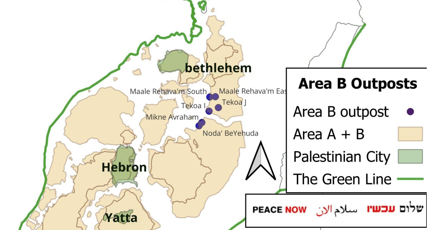
As part of the recent relentless Israeli settlement advancement measures in the occupied West Bank, and only in the timeframe of 6 months, the Bethlehem governorate and its surrounding areas have witnessed an accelerated wave of settlement expansion, manifested through the establishment of 14 new settlements, including in Area B, the retroactive “legalization” of settlement outposts, and the expansion of existing settlement sites. 14 new, legalized, or expanded settlement sites and outposts have been advanced, 6 of them in Area B: “Sheizaf”, “Maale Arugot”, “Masuot Har”, “Gvaot Adulam”, “Mitzpe Darga”, “Yatziv”, “Ya’ar al-Keren”, “Noda BeYehuda”, “Ma’ale Rehavam South”, “Tekoa 9”, “Tekoa 10”, “Ma’ale Rehavam East”, “Ma’ale Rehavam”, “Mikneh Avraham”.
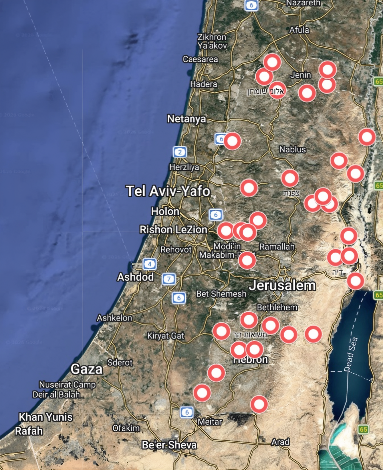
(Google Maps, coordinates of new settlements provided by Peace Now)
The danger of the recent escalation in settlement expansion in the Bethlehem governorate does not stem solely from the high number of new settlement sites, but rather from the strategic position the governorate occupies within the geopolitical geography of the West Bank. Bethlehem constitutes a geographic link between Jerusalem to the north and Hebron and the southern West Bank to the south, along three interconnected axes: the Jerusalem– ”Gush Etzion” axis to the west, the “Tekoa”–Jordan Valley axis to the east, and the “Gush Etzion”–Hebron axis to the south.
The 14 new settlements collectively reinforce and consolidate the settlement blocs surrounding Bethlehem, while creating interconnected settlement corridors that encircle Palestinian communities, restrict Palestinian territorial continuity, and strengthen geographic connectivity among Israeli settlement blocs, as follows:
A. Eastern Bethlehem – Extending Settlement Corridor from “Tekoa” Towards the Dead Sea
In eastern Bethlehem, the approval of 4 settlement sites “Yatziv” in Beit Sahour, “Sheizaf”, “Ma’ale Arugot”, and “Mitzpe Darga” represents a significant step toward consolidating and extending the eastern component of the “Gush Etzion” settlement bloc. These sites were previously established as settlement outposts and were subsequently granted official status under the Israeli government’s decision.
“Sheizaf” is located northeast of the settlement outpost of “Pnei Kedem” (also known as “Abi Hanahal”). Its strategic function is to strengthen settlement contiguity across the eastern section of the “Gush Etzion” bloc and to connect the settlements of “Tekoa” and “Nokdim” with “Pnei Kedem” and the surrounding settlement outposts. “Ma’ale Arugot”, located between “Pnei Kedem” and the settlement of “Metzad (Asfar),” is intended to establish a direct territorial connection between the western and eastern sections of the “Gush Etzion” settlement bloc. “Mitzpe Darga,” situated toward the Dead Sea area, is intended to extend the eastern settlement network beyond the Bethlehem highlands and reinforce the connection between eastern “Gush Etzion” and the Dead Sea region. This trajectory strengthens the territorial relationship among “Tekoa”, “Nokdim”, “Pnei Kedem”, “Metzad, Ma’ale Amos”, and surrounding settlement outposts, while expanding Israeli control over the intervening Palestinian lands.
The expansion of this settlement network is reinforced by the continued establishment and enlargement of settlement outposts in the eastern Bethlehem area, including “Noda BeYehuda”, “Ma’ale Rehavam South”, “Ma’ale Rehavam East”, “Tekoa 9”, “Tekoa 10”, and “Mikneh Avraham”.
This process has been further reinforced by the master plan approved by the “Gush Etzion” Regional Council in July 2026, covering approximately 6,000 dunums of Palestinian land southeast of “Tekoa” in the east. The plan was promoted in cooperation with the “Tekoa” settlement and the “Amana” settlement movement and includes residential areas, tourism facilities, employment zones, agricultural land, open spaces, and an integrated network of roads and infrastructure. According to the council, the plan is intended to promote the development of eastern “Gush Etzion” and secure the long-term expansion and territorial continuity of Israeli settlements in the area.
The impact of these measures extends beyond the expansion of the settlement footprint. The emerging settlement network directly targets the Palestinian communities of Tuqu’ (Tekoa), Al-Minya, Kisan, Beit Ta‘mir, and the surrounding Bedouin communities, including the Rashaydeh and Rawa’in. These communities are located within a strategic area targeted for the eastward expansion of “Gush Etzion” toward the Dead Sea. The consolidation of settlements, outposts, roads, agricultural projects, tourism facilities, and areas designated by Israel as nature reserves restricts Palestinian access to agricultural land and grazing areas and limits the communities’ ability to expand and maintain their traditional rural livelihoods.
Citizen T.A. from the town of Tuqu’, southeast of Bethlehem, stated that all the lands east of the town, specifically in the Tuqu’ wilderness (located east of the town of Tuqu’ and extending toward the eastern slopes overlooking the Dead Sea), have become a pastoral settlement outpost.
According to his testimony, there were 26 families who used to graze their sheep in the wilderness, but earthen barriers were placed to prevent them from entering. Later, an Israeli gate blocking access to the wilderness was moved half a kilometer closer toward the town.
There were four grazing hills that were taken over; they belonged to four families from Tuqu’: Al-Badan, Al-Amour, Al-Sha’er, and Al-Minya.
A large number of the families returned to the outskirts of the town, while others moved to live in the Al-Minya area, which is also a grazing region, but they were later expelled from there as well.
A further dimension of settlement consolidation in eastern Bethlehem is reflected in the transformation of the former “Shdema” military outpost into the “Yatziv” settlement in Beit Sahour’s Ush Ghrab area. “Yatziv” extends Israeli settlement presence into the immediate urban periphery of Bethlehem. Its location in Beit Sahour and Bethlehem’s eastern entrance strengthens Israeli control over a strategically located area while further restricting Palestinian access, development, and urban expansion toward Ush Ghrab.
B. Southern Bethlehem: Settlement Expansion Towards Hebron
Southern Bethlehem represents a strategic axis for extending the “Gush Etzion” settlement bloc toward the northern part of Hebron governorate, benefiting from its location along the northern approach to Hebron. The site of “Ya’ar HaKeren”, located between Beit Ummar and Al-Arroub Refugee Camp, is particularly significant in this context, as its location strengthens the settlement presence along this corridor and threatens the Palestinian geographic space connecting Bethlehem and Hebron.
Besides, the “Gad Natan” settlement, although not located within the geographic boundaries of Bethlehem governorate, extends southward into Hebron governorate. It is situated between the settlement of “Karmi Tzur” and the city of Hebron, adjacent to the eastern side of Israeli Bypass Road 60. Nevertheless, its strategic significance is directly linked to settlement expansion in southern Bethlehem, as Bypass Road 60 constitutes a major axis connecting the Israeli settlements of the “Gush Etzion” settlement bloc with settlements in northern Hebron Governorate. In this context, “Gad Natan” represents a southern extension of the settlement network originating from Bethlehem and contributes to strengthening settlement contiguity along this axis, linking settlement expansion within Bethlehem Governorate to Israeli settlements in Hebron Governorate.
C. Western Bethlehem – a Path to the “Greater Jerusalem” and “Gush Etzion”
Western Bethlehem represents a key axis in the strategy to expand the “Gush Etzion” settlement bloc and strengthen its connection with Jerusalem, given its geographic position between southern Jerusalem and the western villages of Bethlehem Governorate. The newly advanced and approved settlements and outposts in this area carry significance beyond their immediate locations, as they aim to reinforce connectivity between existing settlement blocs and transform the open areas of western Bethlehem into an integrated settlement space serving the broader “Greater Jerusalem” settlement project.
Within this context, the newly advanced settlement sites in the western part of the governorate, particularly “Masuot Har” and “Gva’ot Adulam,” represent key elements in consolidating control over the areas between the “Gush Etzion” settlement bloc and Jerusalem. Their strategic importance derives from their location along the western Bethlehem axis, near the Palestinian villages of Nahalin, Wadi Fukin, Husan, and Battir, which constitute a critical geographic area between the expanding Israeli settlement network and the Palestinian landscape, among which are areas of a UNESCO World Heritage Site, in western Bethlehem.
These sites do not operate in isolation from the existing settlement infrastructure; rather, they contribute to closing geographic gaps between established settlements, including “Beitar Illit,” “Har Gilo,” and the “Gush Etzion” bloc, through the gradual creation of geographic continuity supported by new settlements, related infrastructure, and connecting road networks. This expansion also coincides with broader efforts to consolidate control over strategic and open areas in western Bethlehem, including areas surrounding the Al-Makhrour Valley and the western villages, where controlling undeveloped land constitutes a central component of maintaining geographic continuity between Jerusalem and “Gush Etzion.”
Legal Framework & Analysis
The establishment and expansion of Israeli settlements in the Occupied Palestinian Territory (oPt) constitute a flagrant violation of international law. In its Advisory Opinion of 19 July 2024, the International Court of Justice (ICJ) affirmed that Israel’s continued presence in the oPt is unlawful insofar as it is linked to policies and practices aimed at imposing permanent control, annexation, or the denial of the Palestinian people’s right to self-determination. The Court further confirmed that Israel’s settlement policy, annexation measures, and discriminatory systems of control violate fundamental principles of international law.
Under Article 49(6) of the Fourth Geneva Convention of 1949, the occupying power is prohibited from transferring parts of its own civilian population into the territory it occupies. This prohibition applies to Israeli settlements established throughout the West Bank, including East Jerusalem, which have repeatedly been considered unlawful by the United Nations and the international community. Furthermore, the transfer of parts of the occupying power’s civilian population into occupied territory constitutes a war crime under Article 8(2)(b)(viii) of the Rome Statute of the International Criminal Court, which defines the direct or indirect transfer by the occupying power of parts of its own civilian population into the territory it occupies as a war crime. Accordingly, settlement expansion constitutes not only a violation of the rules governing occupation under international humanitarian law, but may also give rise to individual criminal responsibility under international criminal law.
The construction and expansion of settlements fundamentally alter the demographic composition and territorial character of the occupied territory, exceeding the temporary powers granted to an occupying power under international humanitarian law.
Accordingly, the settlement expansion documented in Bethlehem Governorate must be understood within this legal context. The establishment of new settlements, the “legalization” of existing settlement outposts, the allocation of land through Israeli military orders, and the development of settlement-related infrastructure constitute interconnected mechanisms aimed at consolidating permanent control over Palestinian land, i.e., de facto annexation, clearly prohibited under multiple international legal frameworks. These measures extend beyond the expansion of residential areas; they restructure land use, restrict Palestinian development, and create irreversible facts on the ground that facilitate de facto annexation.
In Bethlehem, recent developments involving 14 settlement sites demonstrate how the settlement enterprise functions as an integrated territorial strategy towards annexation rather than a collection of isolated construction projects. Through the consolidation of settlement corridors along three main axes, the Jerusalem–” Gush Etzion” axis, the Tekoa–Jordan Valley axis, and the “Gush Etzion”–Hebron axis, Israeli authorities are reshaping the geographic organization of the governorate by surrounding Palestinian communities with an interconnected network of settlements and settlement infrastructure.
Accordingly, developments in Bethlehem should not be assessed solely through the number of newly established settlements, but through their cumulative legal and territorial impact: the fragmentation of Palestinian space, the restriction of access to land and resources, and the consolidation of Israeli annexation and control over strategic areas of the Occupied West Bank.
References:
Declassification of Israeli Security Cabinet Decision Reveals Approval of 34 New Settlements in the oPt, Including 6 in Bethlehem – Balasan Initiative For Human Rights
Efrat Settlement: “Lifeline” for Israel’s E-1 and E-2 Settlement and Annexation Plans Report – Balasan Initiative For Human Rights
Israel Allows the Expansion and Entrenchment … | Peace Now
Cabinet Decision on the Establishment of 34 N… | Peace Now
Beyond the New Settlement in Beit Sahour “Yatziv”: A Multilayered System of Land Confiscation, Seizures, Blanket Building Bans and Demolition Orders – Balasan Initiative For Human Rights
Advisory Opinion of 19 July 2024 | INTERNATIONAL COURT OF JUSTICE
تستهدف 6000 دونما من الأراضي الفلسطينية وشرعنة ستة مستوطنات جديدة إقرار مخططات توسعة رئيسية في تجمع غوش عتصيون الاستيطاني جنوب الضفة الغربية المحتلة – POICA