Artas village in the southwest of Bethlehem is among the oldest continuously inhabited rural communities in Palestine, historically shaped by permanent agricultural settlement and sophisticated water-management systems. Its semi-enclosed geographic location between mountain ranges, combined with the abundance of natural springs, enabled the development of a fertile agricultural basin that sustained the village and its surroundings for centuries. The village is known for its Convent, which has been serving it and its surrounding communities for over a century. Artas also served as a key agricultural and water supplier to Bethlehem and Jerusalem through an integrated network of springs, canals, and reservoirs, most notably Solomon’s Pools, whose origins date back to the Roman and Byzantine periods and remained operative for nearly two millennia. This water system constituted a foundational element of the village’s socio-economic stability and regional significance.
Since 1967, however, this historical sustainability has been systematically disrupted by Israeli policies that halted the flow of water, restricted access to land, and imposed structural constraints on development. These dynamics were further entrenched following the Oslo Accords, under which Artas was fragmented into Areas A, B, and C, placing approximately 60% of its land under full Israeli control. This territorial fragmentation has effectively undermined agricultural continuity, prohibited natural urban expansion, and facilitated settlement expansion and physical segregation. As a result, Artas has been subjected to a coercive planning and land regime that infringes upon residents’ rights to land, water, housing, and development, and contributes to a broader pattern of indirect forcible transfer within a prolonged settler-colonial context.
E2 Plan Threat on the Village and the Convent
Field observations by BIHR conducted across Artas reveal a clear and escalating pattern of pressure on Palestinian landowners, within the context of advancing settlement expansion driven by the Efrat settlement and its associated structural plans. The targeted lands, spanning areas classified under different administrative regimes (Areas A and C), form a contiguous geographic space and are being treated as a single strategic unit within a broader colonial spatial reconfiguration of the Bethlehem region.
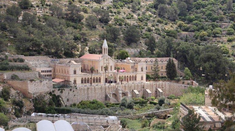
(BIHR, April 22, 2026, Artas Convent.)
Field documentation confirms active concrete settlement activities, including the establishment of settler mobile house units (Caravans), first erected in 2024, the construction of a synagogue on a hill overlooking the village and the Convent, and the hoisting of Israeli flags in elevated, strategically chosen locations, patterns that align with the early stages of outpost establishment, later subjected to retroactive ‘legalizations’.
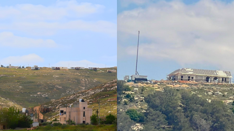
(BIHR, April 22, 2026, Settler Caravans overlooking Hindaza (left), Synagogue being built on confiscated Palestinian lands of Artas (right)).
These developments are accompanied by an intensified Israeli military presence, manifested through regular patrols and an increased visibility of armed forces in and around the affected lands. In parallel, settlers have been observed moving extensively through the area using off-road vehicles, a practice corroborated by consistent testimonies from local landowners and livestock herders. Testimonies further point to recurring acts of obstruction, including denial of access to agricultural lands, and constant anxiety in the fear of losing the lands at any time, which are a source of livelihood and investment for many Palestinians.
Additionally, during April, residents of the Hindaza and Khalayel al-Lawz areas reported repeated incidents involving the same settler groups originating from the hilltop outpost established in Artas. These settlers were observed descending from that site to the vicinity of the communal water well serving Hindaza, where they deliberately tampered with a shared water source used for agriculture and other essential local needs. This pattern underscores a direct operational link between the newly established settlement site in Artas and the ongoing violations targeting vital water resources in the surrounding areas.
Artas Convent: Palestinian-Christian Heritage facing de facto Annexation and settler violence
The gravity of these developments is further compounded by the fact that parts of the threatened lands include sites of exceptional historical, cultural, environmental, and religious significance, most notably the Convent of Artas, known as the “Monastery of the Enclosed Garden,” and Solomon’s Pools. The Monastery of the Enclosed Garden was constructed in 1904 on a land area of approximately 364,000 square meters, following its purchase by the Aragonese Mariano Soler. It was built through the manual labor of more than 120 workers over five years, before being handed over in 1908 to nuns, who used it as a residential and educational institution linked to the city of Bethlehem. Since then, the monastery has functioned as a living religious and social space, where the nuns established a kindergarten in 1974, serving the local Palestinian community, alongside its spiritual and cultural role.
Today, however, this religious and historical site is facing Israeli annexation threats, as Israeli occupation authorities prevent the custodians of the monastery from accessing and using its full lands after having seized large portions of them, in clear violation of property rights and the freedom to manage religious sites. Despite this, the remaining parts of the Convent’s lands are still cultivated with vegetables and trees to preserve the historical character of the land as an evergreen, water-rich “enclosed garden.” The targeting of the Convent and its surroundings indicates that the objective goes beyond land appropriation in its narrow economic sense, extending instead to the disruption of the Palestinian cultural and religious landscape and the erosion of the historical relationship between local communities, their land, and their religious sites, carrying particularly serious implications for the already fragmented Palestinian Christian heritage in the region.
Legal and Analytical Framework
The Artas village is part of the West Bank, as such, it is classified as occupied territory under international Law. Israel, the occupying power, is absolutely prohibited from transferring Israeli civilian population into occupied territories, whether directly or indirectly facilitated through the development and consolidation of settlement infrastructure, including the establishment of outposts and religiously affiliated facilities. Such policies and practices constitute a clear violation of Article 49(6) of the Fourth Geneva Convention. Furthermore, acts involving the effective appropriation of land, restrictions on Palestinian access, and the alteration of its agricultural and built characteristics amount to breaches of Article 46 of the Hague Regulations, which prohibits the confiscation of private property, and Article 53 of the Fourth Geneva Convention, which prohibits the destruction of property unless absolutely required by military necessity. In this context, settlers operate as a direct on-the-ground implementing actor in this pattern, through the establishment of unlawful pastoral or religious outposts and the gradual expansion of control over agricultural lands, often under the protection or acquiescence of the military, reflecting a functional integration between settler activity and the military apparatus in the imposition of durable facts on the ground.
At the historical and cultural level, this pattern acquires an additional dimension in the Artas area, where sites of significant religious and cultural value are located, most notably the Artas Convent, and Solomon’s Pools, which form an integral part of the region’s historical and religious heritage. Settlement expansion in this context is not limited to the physical control of land, but extends to the re-production and redefinition of space through the insertion of settlement structures and sovereign symbols within the vicinity of sites of entrenched religious and historical significance. Such practices, including the establishment of outposts, restrictions on movement, and the conversion of agricultural lands into restricted-access areas, contribute to a pattern of territorial fragmentation embedded within a broader process of demographic and geographic transformation, undermining the continuity of Palestinian presence and eroding rights to land use, access, and territorial integrity.
* For additional context on the cumulative impact of the Efrat settlement on various areas of the Bethlehem governorate, nevertheless E2 plan in Bethlehem including patterns of territorial fragmentation, land confiscation, and settlement expansion, see our previous BIHR update reports: